
Projects
The Green River Potash and Lithium Project
Grand County, Utah — approximately 32,530 acres in the Paradox Basin.
Exploration target summary
| Mineral | Exploration target | Average grade |
|---|---|---|
| Potash | 500M – 950Mtonnes of sylvinite** | 19 – 29% eKCl* |
| Lithium | 0.6M – 1.7Mtonnes of LCE** | 91 – 152 ppm Li |
| Bromine | 3.2M – 9.1Mtonnes of Br₂** | 2,647 – 4,412 ppm Br₂ |
Overview
A 100%-owned land package at scale
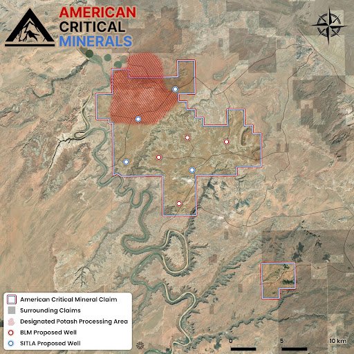
American Critical Minerals holds a 100% interest in 11 State of Utah Potash and Lithium leases, 1,094 Federal placer claims, and 11 Federal potash prospecting permits. Through these leases, claims, and permits, the Company has the ability to explore for potash, lithium, and potential by-products across the entire Green River Project, which combined total an area of approximately 32,530 acres. The Company is authorized to drill a total of 7 exploratory drill holes across the Project (pending bonding of the recently permitted 4 drill holes).
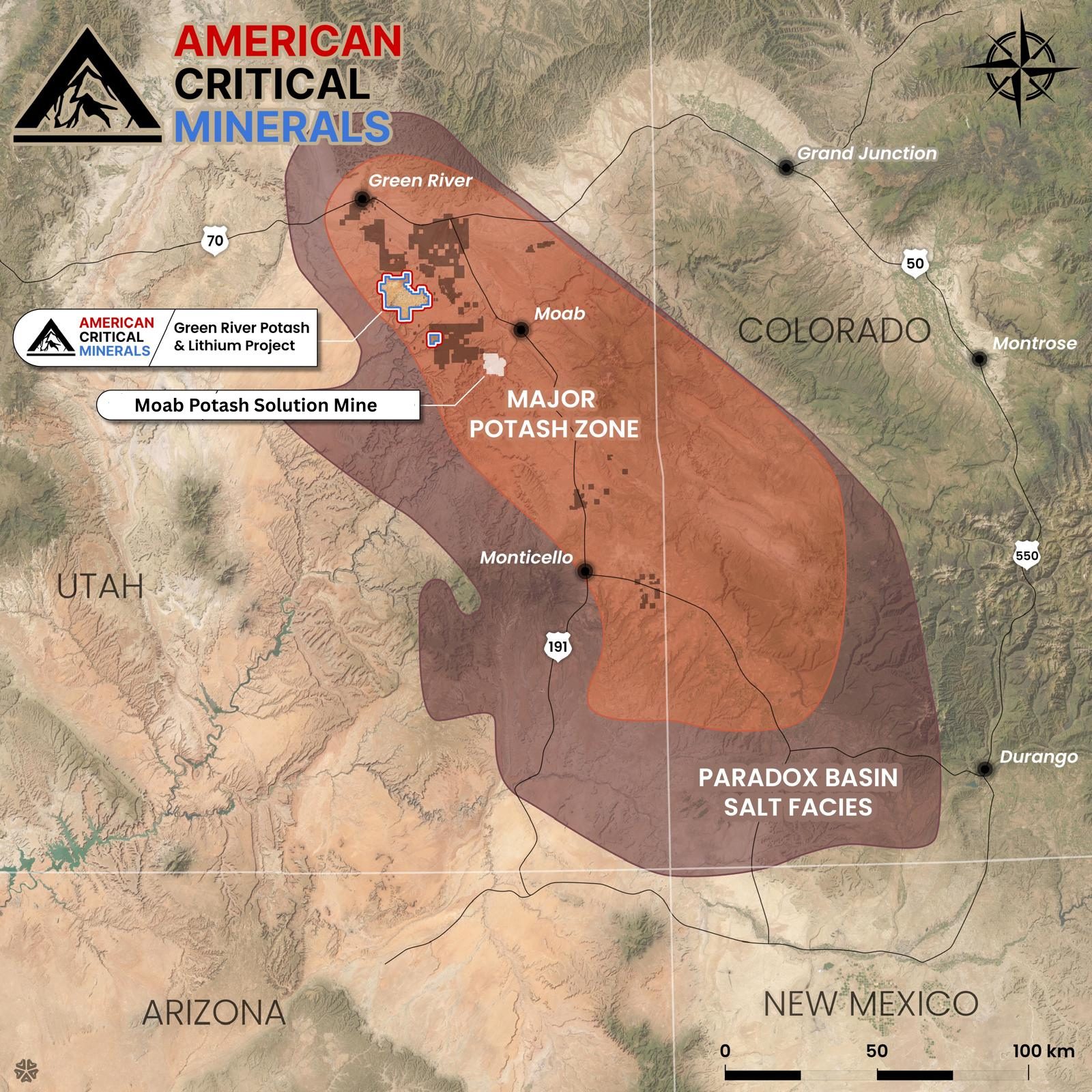
The Project is situated in the renowned Paradox Basin, host to the same geological setting as the nearby currently-active longest-operating United States' solar solution mining potash operation. There, the sedimentary evaporite bed known as Cycle 5 contains the principal potash mineralization that has been mined since 1964; this same cycle extends to our Green River property.
The Moab solar solution plant utilizes low-cost, energy-efficient solution mining and solar evaporation potash recovery. The area's very arid climate, with 300+ days of sunshine per year, combined with excellent infrastructure and year-round access, provides ideal conditions and a highly attractive setting for this style of operation.
Geology
Paradox Basin formation
The Project is located within a geologic province known as the Paradox Salt Basin that extends approximately 160 km (100 miles) in width and 320 km (200 miles) in length in a northwest-southeast direction spanning southeastern Utah and southwestern Colorado. During middle Pennsylvanian age (310–330 Ma) subsidence, the Paradox Basin formed as a restricted shallow marine environment and was filled with 1500–1800 m (5000–6000 ft) of cyclical evaporite sequences with potash noted in 17 of the 29 evaporite cycles (Hite 1960, 1983). As noted in the technical report titled "Amended and Restated NI 43-101 Technical Report Green River Potash and Lithium Project Grand County, Utah USA" dated January 27, 2026 available under the Company's SEDAR+ profile at www.sedarplus.ca, Intrepid Potash is solution mining potash from Cycles 5 and 9 at its Moab Mine.1
[1] American Critical Minerals Corp. has no affiliation to Intrepid Potash or the Moab Mine.
Green River Potash Project location
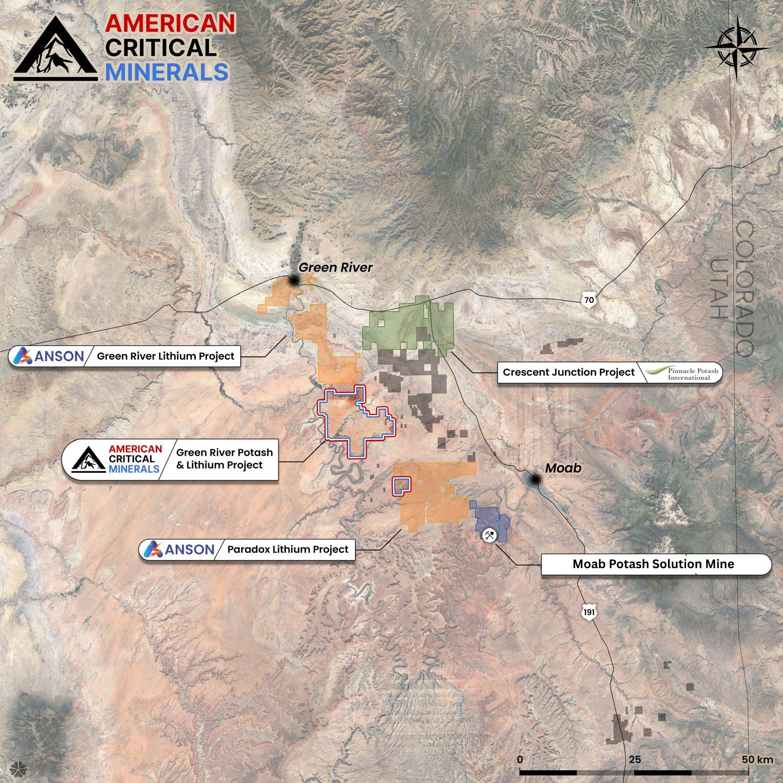
The Project is located in Grand County, Utah, 20–30 kilometers west of Moab and 10–20 kilometers northwest of Intrepid Potash's evaporation pond solution mining operation.1
The Project area has excellent infrastructure close to townsite, rail, highway, power and water.
Technical
Exploration targets
Agapito Associates Inc., a well-respected international engineering firm with recognized local technical expertise in potash exploration, development and solution mining, was commissioned by the Company to provide an independent QP review and NI 43-101 Technical Report of the Green River Project area.
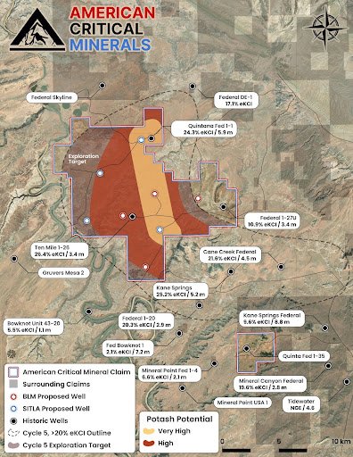
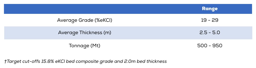
The Property contains potash mineralization in quantities and grade to be considered as targets for further exploration. Potash is present in at least six evaporite cycles on the Property. Of these, Potash 5 is the principal bed of interest. Potash 18 occurs in sufficient quantity and grade to be of interest to the east of the Property. A total of 33 local and regional historic oil and gas wells were utilized in estimating an Exploration Target** underlying the Project area between 500 million and 950 million tonnes of sylvinite with an average grade ranging between 19 and 29% eKCl*; as reported in the Agapito Technical Report**. The majority of these historic wells penetrated the potash beds of interest as indicated by a combination of lithology and down hole geophysical surveys including gamma ray, neutron density, neutron, resistivity and sonic log data. Gamma ray response levels provided the principal basis to infer the location, identification and estimation of potash beds' grade and thickness in oil and gas wells.
The Exploration Targets** for further exploration for lithium and bromine are based on brine hosting intervals within key geologic units, including the Mississippian Leadville Formation and Pennsylvanian Paradox clastic zones 17, 19, 29, 31, and 33. These units were evaluated using porosity, volume, and brine chemistry data, with effective porosity ranging from 5.1–8.5% in the Leadville and 9.9–20.7% across the clastic zones. Lithium concentrations range from 42.9–201.3 ppm and bromine from 2,194–4,741 ppm, based on representative data from adjacent properties.
Using aquifer volumes and porosity estimates, potential brine-hosted metal content was calculated under Low and High Case scenarios, yielding lithium estimates of ~615,000 to 1,710,000 tonnes LCE and bromine estimates of ~3,288,000 to 9,134,000 tonnes Br₂. These ranges reflect current geological uncertainties while illustrating the substantial potential and guiding future exploration.
Preliminary analysis of down-hole electric log data suggests that Potash Cycle 5 is a regionally extensive sylvinite bed in the northern Paradox Basin demonstrating continuous thicknesses and improving in thickness and grade across the Property to the northeast. The best zone of mineralization appears centralized to the northeast quadrant of the Property where inferred potash-bearing Cycle 5 ranges from about 3 to 6 m thick and grades 22 to 25% eKCl*
**References to Exploration Targets should be read in the context of the following Cautionary Note: Exploration Targets are conceptual in nature and there has been insufficient exploration to define them as Mineral Resources, and, while reasonable potential may exist, it is uncertain whether further exploration will result in the determination of a Mineral Resource or support a PEA report under NI 43-101. The Potash, Lithium, and Bromine Exploration Targets are not being reported as part of any Mineral Resource or Mineral Reserve.
*The prefix 'e' in eKCl indicates that the grade was estimated utilizing the response from down-hole gamma ray log surveys and was not measured from chemical analysis of the core.
QP Statement
Dean Besserer, the Chief Operating Officer of the Company and a qualified person for the purposes of National Instrument 43-101 – Standards of Disclosure for Mineral Projects ("NI 43-101"), has reviewed and approval the technical content contained on this website.
Disclaimer
American Critical Minerals cautions that results or discoveries on properties in proximity to the American Critical Minerals' properties may not necessarily be indicative of the presence of mineralization on the Company's properties. All information regarding other companies and/or projects contained in this disclosure has been drawn from publicly available sources. The Company has no affiliation to any of the aforementioned companies and/or projects. The Company has no affiliation to Intrepid Potash or the Moab Mine.